
Imagine, if you will, designing a camera system that not only snaps the picture, but develops the film and scans it into a data format suitable for radio transmission 238,900 miles back to Earth.
That’s what our engineering forebears did back in the 1960s to scout locations for lunar landings.
Now, in an era when it seems that everybody has a smartphone with a digital camera, a team of hackers — in the original sense of the term — is restoring those images from tapes that were squirreled away carefully almost 50 years ago.
Doug Bierend writes in “Wired,” via CNN:
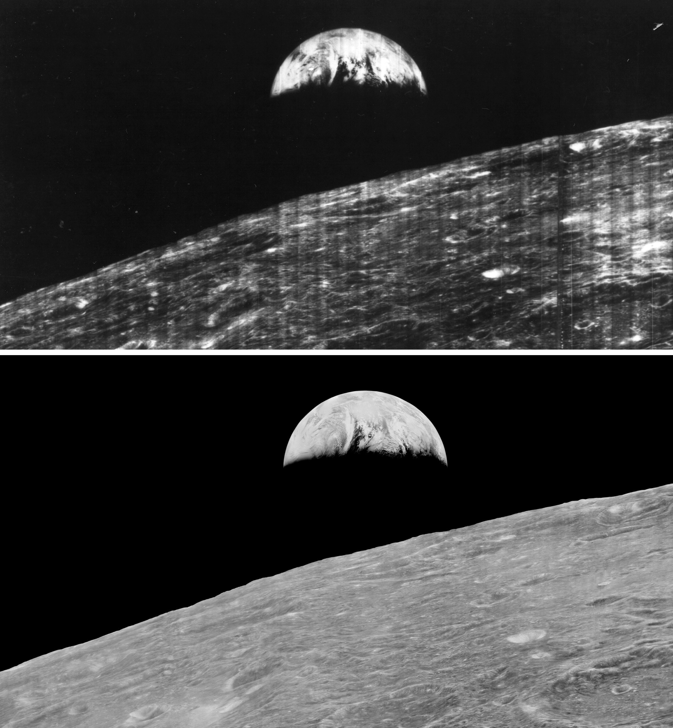
The Lunar Orbiter Image Recovery Project (LOIRP) has since 2007 brought some 2,000 pictures back from 1,500 analog data tapes. They contain the first high-resolution photographs ever taken from behind the lunar horizon, including the first photo of an earthrise.
Thanks to the technical savvy and DIY engineering of the team at LOIRP, it’s being seen at a higher resolution than was ever previously possible.
"No human eye had ever seen this." Here's your peek at @NASA's lost lunar photos: http://t.co/4GZVbdzuSZ pic.twitter.com/Uiv4TBqry1
— CNN (@CNN) July 30, 2014
The technical challenge of getting something like this to work — and to keep working in space — is daunting.
Between 1966 and ’67, five Lunar Orbiters snapped pictures onto 70mm film from about 30 miles above the moon. The satellites were sent mainly to scout potential landing sites for manned moon missions.
Each satellite would point its dual lens Kodak camera at a target, snap a picture, then develop the photograph. High- and low-resolution photos were then scanned into strips called framelets using something akin to an old fax machine reader.
The resulting framelets had to be individually reassembled in Photoshop. After kluging through countless engineering problems (try finding a chemical substitute for whale oil to lubricate tape heads), the LOIRP team was able to single out and reproduce the famous earthrise image.
This proof of concept brought the first NASA funding in 2008, and the team recently completed processing the entire tape collection.
The team’s interest is not just nostalgia for a time when the country dreamed big and delivered. The pictures add to the record of the planets’ natural history.
The images gathered at LOIRP have been coerced into providing even more information than they were intended to. Their data have been used to correct figures from the time about Earth’s arctic ice levels, and have helped identify an El Nino-type event in the ’60s.
All the images and the information gathered from them are being fed into the Planetary Data System, an official repository where mission data from LRO, Mars Observer, Climate Orbiter, and many others are documented.
Thanks to Margaret Bresnahan and John Miller of the MPR Digital Archive staff for drawing our attention to this story.